6 River Cities Offering Lessons in Resilience and How to Adapt to Climate Change

Los Angeles River in a concrete channel / Climate Resolve
"We can consider rivers as city-making landscapes," said Thaisa Way, ASLA, professor of landscape architecture at the University of Washington and organizer of a two-day conference on river cities at Dumbarton Oaks in Washington, D.C. "In river cities, rivers are the agents, offering opportunities for food, transportation, and water, but also liabilities, like drought and flooding." Each river city has a dynamic relationship with its river, so communities that depend on them must always strive to improve their adaptability and resilience. "Rivers can be beneficial or terrifying." In the era of climate change, river cities, with their creative responses to a changing environment, offer useful lessons.
Here are brief summaries of the talks by the few selected to speak at the conference. Way said more than 180 landscape architects, academics, urban planners, and others submitted proposals but just 13 were selected. Way argued this is a sign of the enormous interest in this new field of study. First are stories from the U.S. and then South America, Europe, and South Asia.
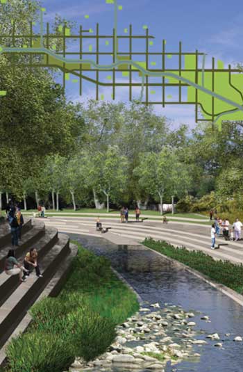
Los Angeles, California, and the Los Angeles River: Vittoria Di Palma and Alexander Robinson, ASLA, both professors at University of Southern California, took us on a history tour of the Los Angeles River. It has always been a "small stream that sometimes turns into a raging torrent during 'rain events.'" After Spanish settlers discovered Los Angeles and then settled there, they plotted out a system of fields separated by inter-connected canals called zanjas. "The city itself was configured by the water supply." While the San Madre river was seen as the "idealized, perfected river," its close relative, the Los Angeles River, never seemed able to behave itself, as it was prone to flooding.
As Los Angeles grew and more farmers came, the desire for predictable water led the city government to begin major efforts to control the once-fluid, complex Los Angeles River starting in the early 1910s, and it was soon fully entombed in a concrete channel by the U.S. Army Corps of Engineers (see image above). By the middle of the 20th century, there was nostalgia for the wild river that had been lost, with poets and artists "creating a vision of its rebirth." But as Di Palma said, "these were idealized visions. People were afraid when it behaved naturally and accepted and loved it when it acted as it should."
In the 1990s, Los Angelenos began to think about how to add parks to the banks of the still channelized Los Angeles River. In 1997, a new master plan was created out of this vision, and by 2005, landscape architecture firms Mia Lehrer + Associates, Civitas Inc., and Wenk Associates created a revitalization master plan for the city government, exploring the "full potential of the 32-mile-stretch of the river in the city." The plan included ecological restoration along with flood control strategies, designs for new bicycle and pedestrian infrastructure, along with development opportunities.
ASLA 2009 Professional Analysis and Planning Honor Award. Los Angeles River Revitalization Master Plan, Los Angeles, California / Mia Lehrer + Associates/ Civitas, Inc./ Wenk Associate
Re-enter the U.S. Army Corps of Engineers, which now has a new mission of ecological restoration and undoing the damage it had done to urban rivers generations before. Following a set of complex studies, featuring an algorithm that examines the per-unit habitat benefits of various ecological restoration approaches, the Corps moved forward with the "alternative 20? proposal, under great political pressure, including from the White House. That proposal is not the most cost-effective according to the calculations, but it provided what the city government and local non-profits, with their broader urban revitalization goals for the river corridor, more of what they wanted.
The negotiations with the city were complicated. "Congress doesn't fund the Corps to do urban revitalization. They are not going to pay for a High Line. Everything must support ecological restoration." The Corps has agreed to work with the city so their effort to restore the river ecology synchs up with the city's efforts to provide recreation opportunities. But the bottom line is "the Los Angeles River can't flood again. The compromise is we need to keep people safe and restore the river to health."
Pittsburgh, Pennsylvania, and the Monongahela and Allegheny Rivers: The Allegheny River comes right into the city, said Ray Gastil, head of planning for Pittsburgh. "It's not a sacred river." When Pittsburgh was the heart of steel manufacturing in the U.S. in the early 1900s, the rivers flowing through Pittsburgh were so toxic they were actually poisoning the population. This is because they were not only used as industrial infrastructure but also as a dump for sewage. When 620 died in a typhoid outbreak, the city started to get serious about improving their water quality, which they realized was linked with the health of the river. "Finding the causal links between water and disease took a long time to figure out."
By the 1920s, the legacy of steel manufacturing was beginning to take its toll. "The city began to realize that the deleterious effects on the air and water were not sustainable." By 1923, some local organizations began arguing that "the riverfront should be a shared benefit and workers need a place to recreate," but there was no public space, because the land was just too valuable for industrial use. A plan was created to set aside some parks that were to be publicly owned. From the 1920s to 1950s, the point where the Ohio River meets the city was turned into a park, and then, from the 1970s to the 00s, bike trails came, along with the rise of adaptive reuse projects and a new waterfront tech park. Heinz Field, a huge stadium, was set right on the waterfront, with one side open to the Allegheny. Cut to 2015, and the city is still working on the Three River Parks plan, created in 2001, which has created 13 miles of inter-connected green space and trails and spurred $4 billion in riverfront development, and harks back to early 20th century plans to make the waterfront publicly accessible.

Allegheny Riverfront Park / Michael Van Valkenburgh Associates
A new master plan by Perkins Eastman will turn a 170-acre post-industrial plot on the Allegheny riverfront into a mixed-use development that will also preserve some of the old steel mills. But for the most part, Pittsburgh's mill past has been erased. "There are no romantic feelings about their role in the city. Pittsburgh wants to move away from being a city of smoke."

Allegheny Riverfront Vision Plan / Perkins Eastman
San Antonio, Texas, and the San Antonio River: David Malda, ASLA, a landscape architect with Gustafson Guthrie Nichol, said San Antonio has long struggled with either an excess or total lack of water. Like a young Los Angeles, early San Antonio had a series of canals, called acequias, that sustainably conveyed water to farmers. By 1910, the acequias were largely replaced by wells, which eventually took their toll on the groundwater. The San Antonio River's flow was eventually negatively impacted, to the point where the city had to install multiple pumps to move river water into the city. But, also, during heavy storms, the system broke down, caused flooding. In 1921, 50 people lost their lives due to flooding along the San Antonio River.
Instead of paving over the river and turning it into a channel for sewage, which many wanted to do, local architect Robert Hugman proposed constructing a cut-off channel, a loop or riverwalk, that people could walk in a circle downtown. In the 1930s, work began in earnest on the 2.5-mile-long San Antonio Riverwalk, which slowly became what it is today over the following decades. "San Antonio invented the idea. They could have a piece of a river without the risk." Paths, which visitors had to step down to river level to visit, were designed to be intentionally narrow.

San Antonio Riverwalk / The Flast List
Over the years, the Riverwalk loop itself was expanded, including a naturalistic segment in the 1960s, another segment in the late 80s, and a final one that opened in 2011. Over the years, additional underground infrastructure that redirects excess water out of the loop was constructed to ensure the Riverwalk would not become a danger during floods.
At the edge of the Riverwalk loop, Gustafson Guthrie Nichol is designing a new civic park downtown, which will revamp a site cleared for the 1968 Hemisfair, a broader urban renewal effort. The new park will refer to the original great plains and coastal plains ecosystems that once characterized this area, and feature a network of acequias that refer to the original system of water infrastructure. Malda made the case for doing deep historical analysis before undertaking a landscape architecture project. "It's not nostalgic but strategic. We need to understand how the park will fit into the greater pattern. We can then do creative reconstruction from a landscape narrative that draws people and places through time."

Civic park at the Hemisfair / Gustafson Guthrie Nichol
In South America: São Paulo, Brazil, and River Headwaters: Cornell University landscape architecture professors Brian Davis and Amelia Jensen argue that rivers form a new borderland within the the Brazilian mega-city São Paulo, which is on a high plateau that also serves as the headwaters for multiple rivers. As the city expanded and the population moved down from flood-proof hills, more communities took root along riverbanks. Rivers have been largely channelized, as the goal has been to move flooding water through the city as fast as possible.
But that approach has failed, so the state government created a set of piscinão, large water detention basins that are meant to "act as a solution for flooding." While the state built these piscinão, it's not clear who maintains them. Today, there are "jurisdictional ambiguities" at the borders where city and rivers meet. Many piscinão are filled with sewage and trash, and have become major sources of complaints by those unfortunate enough to live near them. A few have been well-tended by the local communities, planted with trees, so they form multi-use community infrastructure: parks when rivers run low, and detention basins during severe rain events.

Piscinão Guarau, Sao Paulo / Encalso
In Europe: the Lyon, France, and the Rhône and Saône Rivers: In Lyon, France, these two rivers converge forming a peninsula in the heart of this 2,000-year-old metropolis, explained Michael Miller, a historian at the University of Miami. This makes for city with many banks: "There are two left banks and two right banks." It also makes Lyon a true river city. "It's a 'riverness' is connected with the city." Miller explained how the city has since its days as a Roman center in Gaul has wrapped itself around the rivers but over time the confluence has changed. "Islands were joined together to form the peninsula, extending the size of the city. This was done for beauty and function." Trees line river-facing promenades, even those prone to flooding.

Lyon, France in 1860. Adolphe Rouargue – Archiv "Deutschland und die Welt" / Wikipedia
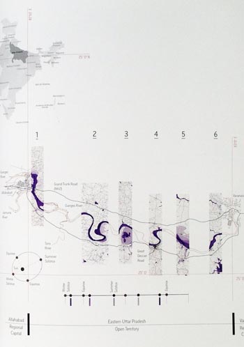
In South Asia: Allahabad, India, and the Yamana and Ganges Rivers: In Uttar Pradesh, India, the Hindu mecca Allahabad is a source of fascination for Columbia University architectural historian Anthony Acciavatti, author of Ganges Water Machine. Allahabad, which sits at the meeting points of the Ganges and Yamana Rivers, is always responding to seasonal change; it's a "dynamic agropolis," an agricultural economy deeply dependent on the monsoon and the shape-shifting rivers as they shrink and flood. Acciavatti has been mapping the fluvial changes over a decade, documenting the soft edges of the rivers with GPS and panoramic photos and creating handsome maps out of his data.
He is also tracking the shift from centralized water management to a decentralized one involving small tube wells that pull straight from groundwater, and the impact of this on the form of the city. He eventually wants to create a sort of hybrid atlas and almanac, a "dynamic atlas that would explain how the conditions of people, weather, and infrastructure interact, and how this interaction changes."
Ganges River Machine / ArchDaily
Shahjahanabad, India, and the Yamana River: Jyoti Pandey Sharma, a professor of architecture at Deenbandhu Chhotu Ram University of Science and Technology, explained how "Agra wasn't cutting it" for Mughal Emperor Shahjahan in the 17th century, so he moved his capital down river, creating Shahjahanabad, in the Delhi Triangle. Shahjahanabad became the "seat of sovereignty and the caliphate; it was the epicenter of supreme power and religion." In this city, the Qila was the embodiment of imperial authority. It was the "celestial ruler's landscape," with elaborate architecture set in prescribed formations, while just outside, the river was wild. Access to the city's riverfront was largely democratic, but in front of the Qila, it was restricted. The river, at least symbolically, was tamed to serve the needs of the emperor. Water from the Yamana River flowed into a series of canals brought into the capital. River water provided "thermal comfort, and visual, tactile, and auditory pleasure."

Shahjanahabad / Kamit.jp
By the time the British took over in the 1800s, the perception of the river changed. It became "an agent of discord" and a source of malaria. Shahjahanabad was no longer a picturesque river city. Today, the Yamana is a river of "human filth and pollution."

